Time-of-arrival Tracking
Location information is a requirement common to many applications, and though GPS is now a ubiquitous technology, the size, cost and energy consumption of GPS receivers limit their use. For example, fewer than 15 percent of bird species are large enough to carry currently available GPS trackers, which require a relatively heavy battery. To address this limitation, we designed and built an alternative radio-frequency locating system that uses pseudorandom-encoded transmissions from very small mobile units (tags) to locate mobile transmitters using a matched filter detector approach based on time-of-arrival. This method uses 1000x less energy at the tag than GPS, is capable of tracking several hundred transmitters simultaneously with no operator intervention, has high spatiotemporal resolution (+/- 10 m, 1 second position updates), and uses tags (Fig 5.A) that are inexpensive (<$50), long-lived (years), and lightweight ( less than 1 gram)
Related Publications
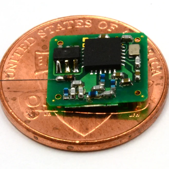
Software-defined Tags
Existing wildlife monitoring devices (tags) are special-purpose custom designed tools that are built specifically for a particular user or experiment. This makes them slow to produce, expensive, and difficult to adapt to new study scenarios or technological changes. Instead, we have recently designed and built a software-defined tag that is very lightweight (300mg) and is solar-powered, allowing an indefinite lifetime. This tag can be adapted for use with existing tracking receivers (OOK), data telemetry receivers (ASK,FSK,FM), or with time-of-arrival receivers.
Terrestrial Autonomous Acoustic Recorder
Like the marine application above, terrestrial acoustic signals can be used to assess wildlife behavior, including abundance, and spatio-temporal patterns. Synchronized recorders permit arrival-time based estimates of position.
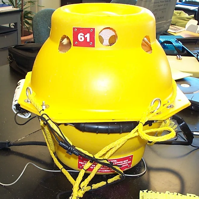
Autonomous Ocean-bottom Acoustic Recorder ("popup")
Marine animals have evolved to utilize acoustic communication; marine animal scientists can exploit natural vocalizations to learn about wildlife behavior without ever interacting with (tagging) the animal. We led a team of engineers at the Cornell Lab of Ornithology who designed a fleet (>200) of underwater recording systems that have been deployed throughout the world's oceans. After deployment, these recorders sit on the ocean floor, recording according to a schedule, and can do so for more than a year. When commanded to resurface, the "popup" releases an anchor and floats back to the surface for retrieval, after which its data can be read.
Energy Harvesting
Free-flying organisms can carry a small percentage of their body mass as additional payload; for birds the widely-used guideline is 3%. This means that roughly half of all bird species can carry no more than 1 gram of added payload, which imposes a very tight mass budget on the design of any systems added to them in order to monitor their behavior. The mass-specific energy density of electro-chemical batteries has improved slowly over the years, but there is currently no battery than can provide sufficient energy storage per gram to enable multi-year tag lifetimes, a duration which has significant behavioral relevance. For this reason, we have investigated and developed various forms of energy harvesting as a supplement to tag batteries, focusing on vibration harvesting (for nocturnal animals) and solar harvesting. Because the exact amount of energy that will be harvested during the tag's deployment cannot be known a priori, this work also incorporates energy-aware computing to manage the energy stored on the tag. 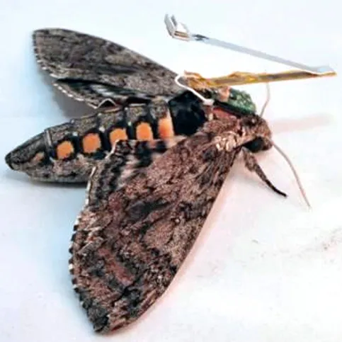
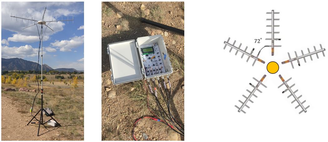
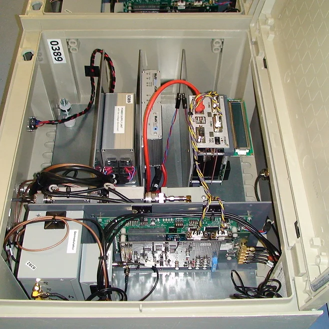
Direct of Arrival Tracking
There are various options for optimially tracking the transmission source of low-powered radio frequency transmitters, which avoid the enery costs of GPS-based tracking systems. Many of these systems use software defined radios. While these devices are helpful, they are also expensive and complicated to operate, especially in the case of biologists who wish to study the movements of animals. Estimating the direction of arrival (DOA) of a transmission event from RF tags at receiver stations, is a type of tracking method that does not require high-end hardware. If there is a grid of receiver stations, the DOA estimates at each station can be used to infer an approximate location of the transmission source. In order to consturct a simple system, we used commercially available 5-channeled configurable radio receiver (Sensor Station) and low-powered RF transmission tags from Cellular Tracking Technologies. The receivers are used to build individual receiver stations where Yagi-Uda directional antennas are connected to the Sensor Station and mounted up in a circular pattern to receive transmissions from all directions. Multiple stations like this are set up around the area of interest to estimate the location for the transmitter tags. The Received Signal Strength Indicator (RSSI) data received at the radio channels are used to develop various DOA estimation algorithms, that make use of Mult-modal Gaussian functions, least squares optimization, random forest regression and neural networks. By utilizing these DOA estimation algorithms, we can generate spatial probability maps with respect to each receiver and isolate the coodinates that have the highest likelihood of being a transmission location.